|
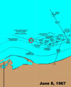

USS Liberty Course
This map shows the course of USS Liberty on June 8th, the Israeli recon flights (shown in circles), and the attacks by air and sea forces
|
|
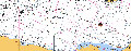
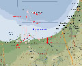 Egyptian Radar Plots
This map shows US intercepts of Egyptian radar plots from the time before, during, and after the Israeli attack on USS Liberty
|
|
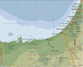
General Map
This map shows the general geographic area of USS Liberty's cruising station, the location of the attack, and the bases of the Israeli air and naval forces.
|
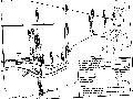
Israeli Map
This map is from the 1981 Israeli Defense Forces Report and purports to show the positions of the Israeli air and see forces, as well as the position of USS Liberty, during the attack.
|
|
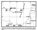
Position of US Forces on June 8, 1967
This map shows the positions of the various US forces on June 8th and 9th. In particular, it shows the distance between the US aircraft carriers and the position of USS LIberty during and after the attack.
|
| 
Positions of US SIGINT platforms
In addition to USS Liberty, the United States maintained two airborne signals intercept (SIGINT) platforms. This map shows the tracks of these platforms.
|
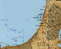
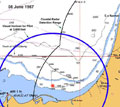
Israeli Costal Radar Coverage
This map shows the range of the Israeli coastal radar defense net. USS Liberty's course for most of the June 8th daylight hours leading up to the attack was within Israeli radar coverage. USS Liberty was the largest radar target in this zone.
|
|
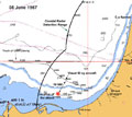
USS Liberty's course, June 8, 1967
The plots on this map reflect the positions of USS Liberty hourly, as recorded in the ship's log..
|
| 
Limit of the visual horizon for a pilot at 3,000 feet
This diagram shows the limit of a pilot's visual horizon at 3,000 feet. Had there been a warship in the area, both the ship and its high speed wake would have been visible to the Israeli pilots.
|
)
)
)
)
)
)
)
)
)